Shingo Obata PhD in Forestry and Natural Resources/Forest Management/Forest Inventory/Spatial Analysis/Remote Sensing/Machine Learning

About


Shingo Obata

(小幡進午)

Postdoctoral Research Associate

Google Scholar
Research Gate

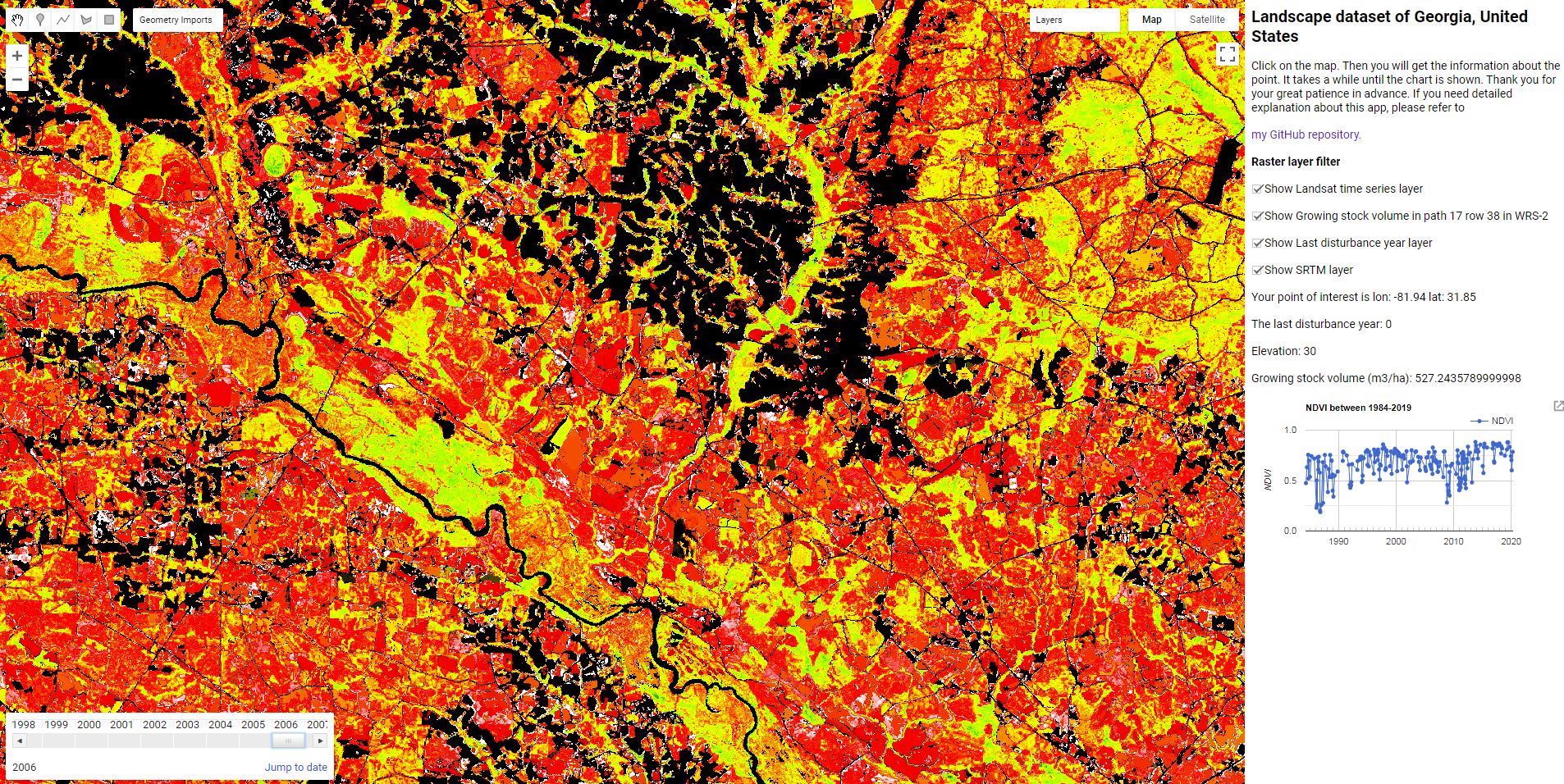
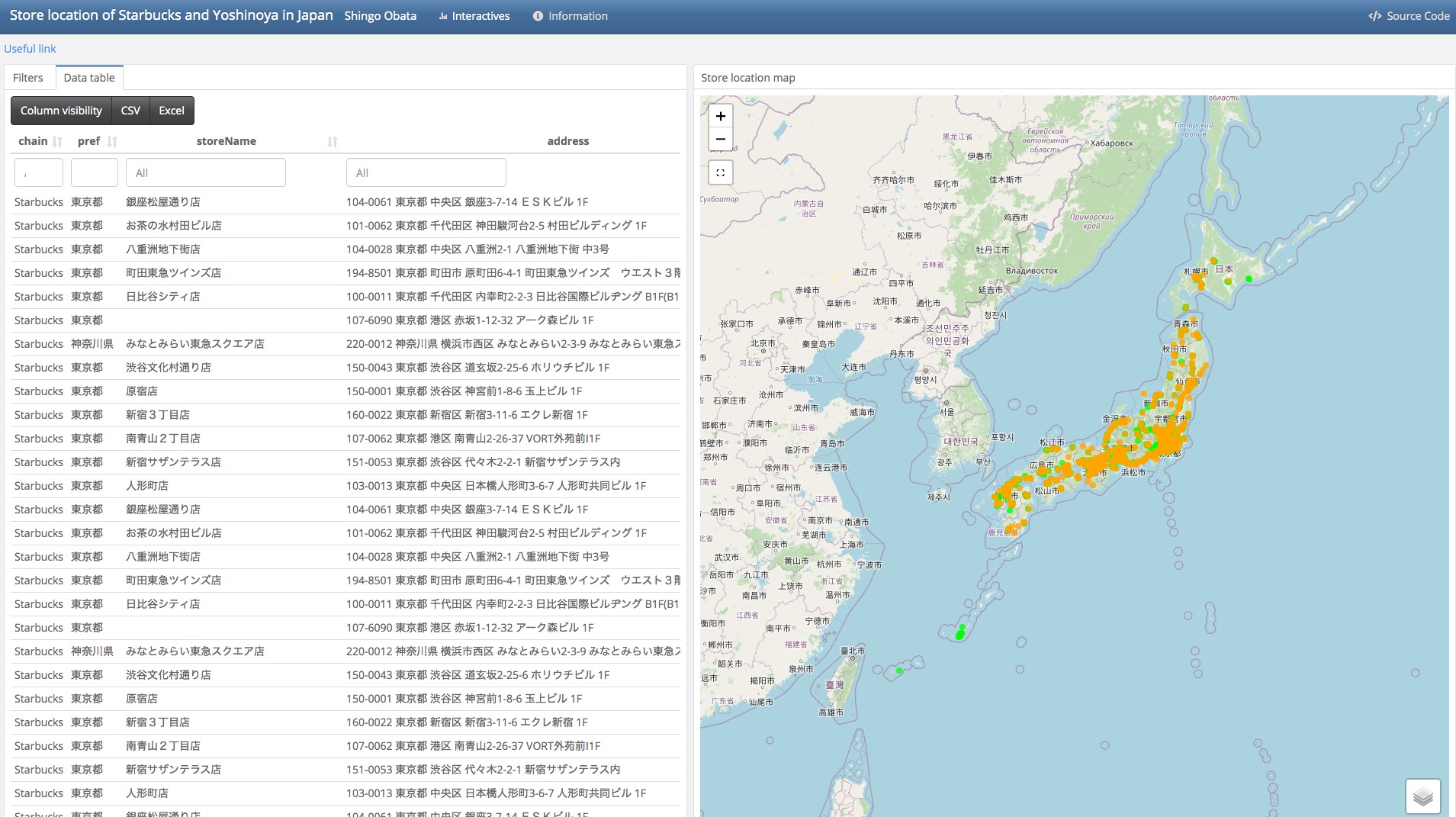
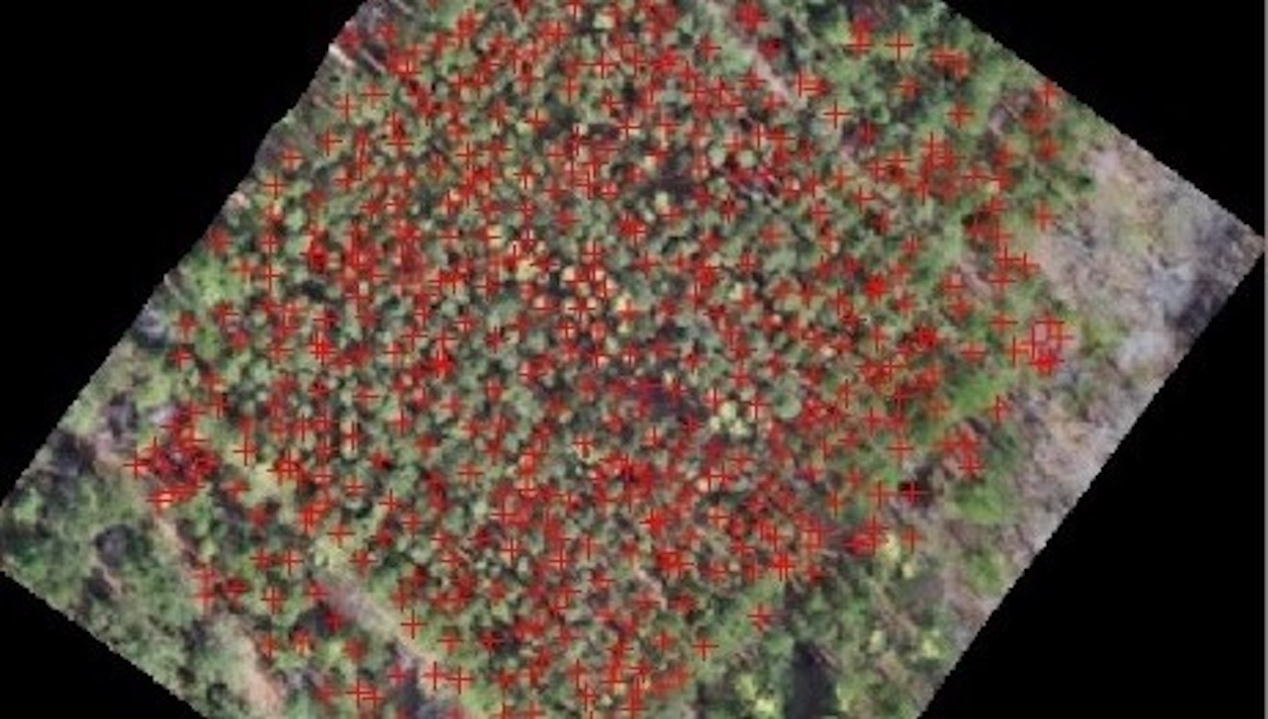
I am a postdoctoral research associate at the National Institute for Mathematical and Biological Synthesis. My research interests are forest management and remote sensing. My main focus is national-scale forest inventory analysis in the U.S. South and Japan using remote sensing data and field inventory data. In my research I intensively use R, Python and Google Earth Engine. In my free time I enjoy hiking, cooking and running.

Education

  • 2016 - 2020: Ph. D. in Forestry and Natural Resources, the University of Georgia, Georgia, USA
  • 2014 - 2016: MSc in Forest Science, the University of Tokyo, Tokyo, Japan
  • 2010 - 2014: BA in Agriculture, the University of Tokyo, Tokyo, Japan
  • Experience

  • Apr 2022-: Project Assistant Professor, The Institute of Statistical Mathematics, Tokyo, Japan
  • Oct 2020 - Mar 2022: Postdoctoral Research Associate, the National Institute for Mathematical and Biological Synthesis, Tennessee, USA
  • Fall 2016 - Fall 2019: Teaching assistant, University of Georgia, Georgia, USA
  • Grant

  • 2016-2019: Student Exchange Support Program from Japan Student Services Organization ($31,654 for each year)
  • Portfolio


    Works

    My works published/presented since 2017.


    Refereed Articles

  • Obata, S., Cieszewski, C. J., Lowe, R. C., & Bettinger, P. (2021). Random Forest Regression Model for Estimation of the Growing Stock Volumes in Georgia, USA, Using Dense Landsat Time Series and FIA Dataset. Remote Sensing, 13(2), 218. => Article link
  • Obata, S., Bettinger, P., Cieszewski, C. J., & Lowe III, R. C. (2020). Mapping Forest Disturbances between 1987-2016 Using All Available Time Series Landsat TM/ETM+ Imagery: Developing a Reliable Methodology for Georgia, United States. Forests, 11(3), 335. => Article link
  • Zhang, S., Bettinger, P., Cieszewski, C., Merkle, S., Merry, K., Obata, S., He, X., & Zheng, H. (2019). Evaluation of sites for the reestablishment of the American chestnut (Castanea dentata) in northeast Georgia, USA. Landscape Ecology, 34(4), 943–960. => Article link
  • Obata, S., Cieszewski, C. J., Bettinger, P., Lowe III, R. C., & Bernardes, S. (2019). Preliminary analysis of forest stand disturbances in Coastal Georgia (USA) using Landsat time series stacked imagery. FORMATH, 18, 1–11. => Article link
  • Obata, S. (2018). Estimation of forest stand disturbance through implementation of vegetation change tracker algorithm using Landsat time series stacked imagery in coastal Georgia. Mathematical and Computational Forestry and Natural-Resource Sciences, 10(1), 32.
  • Akbulut, R., Bettinger, P., Ucar, Z., Obata, S., Boston, K., & Siry, J. (2017). Spatial Forest Plan Development Using Heuristic Processes Seeded with a Relaxed Linear Programming Solution. Forest Science, 63(5), 518–528. => Article link
  • Akbulut, R., Ucar, Z., Bettinger, P., Merry, K., & Obata, S. (2017). Effects of forest thinning on static horizontal position accuracy collected with a mapping-grade GNSS receiver. Mathematical and Computational Forestry & Natural-Resource Sciences, 9(1), 14–21. => Article link
  • Presentations

  • Obata, S., Schroeder A. T., Papeş, M.(2021a, December 7). Improvement of post-stratified forest volume and area estimation using stereo-imagery based point cloud in the Southeastern United States​. [Oral presentation at 13th southern forestry and natural resource management GIS conference, Athens, GA, United States.].
  • Obata, S., Schroeder A. T., Papeş, M.(2021b, September 22). Terrestrial Laser Scanning data processing with R. [Online oral presentation at Forest Inventory and Analysis Terrestrial Laser Scanning (TLS) Demonstration].
  • Obata, S., Bettinger, P., Cieszewski, C., & Lowe III, R. C. (2019a, March 21). Estimation of the growing stock volume of the forest stands in Georgia, USA using FIA data [Oral presentation at 130th Annual Japanese Forest Science Meeting].
  • Obata, S., Cieszewski, C., Bettinger, P., & Lowe III, R. C. (2019b, December 9). The estimation of the growing stock volume of the forest stands in Georgia [Oral Presentation]. 12th southern forestry and natural resource management GIS conference, Athens, GA, United States.
  • Obata, S., Cieszewski, C., Bettinger, P., Lowe, R. C., III, & Bernardes, S. (2018a, October 2). Estimating the last distutbance year of forest stands in Coastal Georgia using all the available Landsat imagery with Google Earth Engine [Poster]. ForestSAT 2018, Maryland, United States.
  • Obata, S., Cieszewski, C., Lowe, R. C., III, Bettinger, P., & Bernardes, S. (2018b, March 16). Estimation of forest stand disturbance in coastal Georgia. FORMATH FUKUOKA 2018, FUKUOKA.
  • Obata, S., Cieszewski, C., Bettinger, P., Lowe, R. C., III, & Bernardes, S. (2017a, August 29). Spatiotemporal analysis of Landsat imagery for assessment of disturbance tracking in coastal Georgia [Oral Presentation]. Symposium on System Analysis in Forest Resources 2017, Seattle, United States.
  • Obata, S., Cieszewski, C., Bettinger, P., Lowe, R. C., III, & Bernardes, S. (2017b, December). Estimation of forest stand disturbance through implementation of Vegetation Change Tracker algorithm using Landsat time series Stacked imagery in coastal Georgia [Poster].
  • Contact Me